
Abstract
Widespread changes of agricultural land use occurred in Eastern Europe since the collapse of socialism and the European Union's eastward expansion, but the rates and patterns of recent land changes remain unclear. Here we assess agricultural land change for the entire Carpathian ecoregion in Eastern Europe at 30 m spatial resolution with Landsat data and for two change periods, between 1985–2000 and 2000–2010. The early period is characterized by post-socialist transition processes, the late period by an increasing influence of EU politics in the region. For mapping and change detection, we use a machine learning approach (random forests) on image composites and variance metrics which were derived from the full decadal archive of Landsat imagery. Our results suggest that cropland abandonment was the most prevalent change process, but we also detected considerable areas of grassland conversion and forest expansion on non-forest land. Cropland abandonment was most extensive during the transition period and predominantly occurred in marginal areas with low suitability for agriculture. Conversely, we observed substantial recultivation of formerly abandoned cropland in high-value agricultural areas since 2000. Hence, market forces increasingly adjust socialist legacies of land expansive production and agricultural land use clusters in favorable areas while marginal lands revert to forest.

Content from this work may be used under the terms of the Creative Commons Attribution 3.0 licence. Any further distribution of this work must maintain attribution to the author(s) and the title of the work, journal citation and DOI.
1. Introduction
Humanity derives essential goods and services from land use, but simultaneously land use changes have become a primary driver of global environmental change and caused significant biodiversity loss as well as the deterioration of ecosystem services (Tilman et al 2002, Foley et al 2005). Changes in agricultural land use were particularly widespread, with ample consequences for humans and nature. One major environmental concern is the rapid expansion of croplands and pastures at the expense of tropical and subtropical forests, and the various adverse consequences for biodiversity and carbon budgets (Sala et al 2000, van der Werf et al 2009). But while agricultural land use continues to expand in many tropical regions, areas used for agriculture tend to decrease in the temperate zone. A large body of research has been devoted to understanding agricultural expansion in tropical settings, but the patterns and processes of the decrease of agricultural land are less well understood (Kuemmerle et al 2009, Ramankutty et al 2010, Hostert et al 2011). This is unfortunate, because abandonment of agricultural land has strong implication for agricultural production and affects carbon pools (Vuichard et al 2008), biodiversity (MacDonald et al 2000) and food security (Schierhorn et al 2012). A better understanding of the rates and spatial patterns of agricultural land abandonment is therefore crucial.
One of the most drastic recent episodes of land change that resulted in massive rates of agricultural abandonment occurred after the collapse of socialism in the countries of the former Soviet Union and in Central and Eastern Europe (CEE) (Henebry 2009). The socialist agricultural system was strongly subsidized in these countries with guaranteed output and input prices and high land and labor inputs, often with the aim to increase self-sufficiency in agricultural production (Csaki 1990, Lerman et al 2002). State support largely disappeared following the collapse of socialism and agricultural production was economically no longer viable in many areas due to price liberalizations, dilapidated infrastructure and increasing competition with other economic opportunities, leading to production decreases and rural emigration (Rozelle and Swinnen 2004, Mueller and Munroe 2008, Mueller et al 2009). Consequently, vast areas of agricultural land were abandoned. Abandoned lands subsequently experienced natural succession and many areas have now reverted back to young forests, contributing to the forest transition in Eastern Europe (Taff et al 2010). However, most evidence regarding the extent of agricultural abandonment to date relies on case studies, while the spatial and temporal patterns for large, contiguous areas are not well understood.
Agricultural abandonment tends to cluster in areas with comparatively low suitability, such as mountain areas, while fertile lands often continue to be cultivated (MacDonald et al 2000, Ioffe et al 2012, Prishchepov et al 2013). However, today's agricultural production in Russia and CEE is often below the potential yields under the given environmental conditions and therefore these lands represent interesting options for increasing food production (Foley et al 2011, Schierhorn et al 2012). Given the recent rises in global agricultural commodity prices, abandoned agricultural land in post-socialist countries today represents an attractive source of income and increasingly becomes a target for investors (Deininger 2011, Visser and Spoor 2011). In the face of the recent increase in agricultural commodity prices, quantifying recultivation of abandonment lands can shed light on the effects of growing profit opportunities in agriculture on agricultural land use.
The eastward expansion of the European Union may also have contributed to recultivation of abandoned lands. New member states in 2004 included, among others, the Czech Republic, Hungary, Poland and Slovakia and in 2007 Romania became part of the EU. New member states became subject to the influence of the European Union Common Agricultural Policy (EU CAP), which grants direct subsidy payments in support of agricultural production and rural development. However, little is known about how the EU accession has affected agricultural land change in CEE countries.
The focus of this study is to map and analyze agricultural land change across the Carpathian ecoregion in Eastern Europe since before the collapse of socialism until 2010 at 30 m (i.e. Landsat) spatial resolution. The Carpathians are Europe's largest mountain region and extend over seven countries (Austria, Czech Republic, Slovakia, Poland, Hungary, Ukraine and Romania). All countries except Austria were under socialist governance between 1945 and 1991 and all countries except Ukraine are now members of the EU. The Carpathians are a highly diverse ecoregion, which historically translated into a large variety of land use structures (Turnock 2002) that may have been affected differently by the contrasting post-socialist reform policies and economic development trajectories. However, no consistent and spatially explicit dataset on recent land change exists for the Carpathians as a whole.
We utilized Landsat satellite imagery to fill this gap. Landsat imagery is a great data source for retrospective land change assessments, as it provides a continuous record of synoptic observations since decades with 30 m spatial resolution and adequate spectral detail. Recent changes in data policy as well as advancements in data quality, preprocessing and analysis algorithms have greatly improved the potential of Landsat data to quantify agricultural land change for large areas (Wulder et al 2012). Taking advantage of these developments, our objectives were to (a) quantify the spatial and temporal patterns of agricultural land change in the Carpathians between 1985 and 2000 as well as between 2000 and 2010, and to (b) assess and compare environmental and agro-ecological characteristics of areas where agricultural land change occurred. The year 1985 was chosen as this is roughly the earliest year that Landsat Thematic Mapper data is available over Europe while land use was still fully controlled by socialist land management regimes. The year 2010 should capture the situation following the EU accession of most Carpathian countries. The year 2000 lies in the middle between socialism and EU accession and post-socialist transformation processes are potentially captured in satellite imagery while processes related to the EU accession are only beginning to trigger spatial changes.
2. Data and methods
Our study region is the Carpathian ecoregion (CERI 2001) including intersecting administrative units (Nomenclature of Territorial Units for Statistics, Level 3—NUTS3), resulting in an area of approximately 380 000 km2 (figure 1). Elevation in the study region ranges from 400 m in the plains to 2500 m in the Southern and Western Carpathians. A wide range of agricultural land use types exists, ranging from large scale, intensively managed cropland to subsistence agriculture and kitchen gardens. Cropland in the region is predominantly used for cereals (wheat, corn, barley, rye, oat) and legumes (potatoes, sugar beets, peas), but also to grow energy crops (e.g., rapeseed/canola). Perennial crops exist in the form of fruit tree orchards, vineyards or hop fields. Grassland is utilized as pastures or hay fields and at higher elevations meadows are used for seasonal sheep grazing.

Figure 1. Overview of the Carpathian study region (yellow), the ecoregion boundaries (black) and country borders (white). Additionally, the coverage of Landsat footprints is shown (magenta), which were used to produce three seasonal image composites (spring, summer and fall) for three reference years (1985, 2000 and 2010).
Download figure:
Standard image High-resolution imageThe majority of agricultural land in the Carpathian countries was under collective or state farm management during socialism, except in the Polish Carpathians where private farms persisted (Lerman 1999, Kozak 2010). After 1989, private property was reintroduced and collectivized lands were restituted, auctioned or distributed to farmers, historical owners or their heirs, which led to considerable structural change in agriculture including the emergence of many small fragmented farms alongside large private cooperatives (Sarris et al 1999). The Carpathian ecoregion hence offers a diverse and, from a remote sensing point-of-view, challenging region to study due to the prevailing heterogeneous landscapes and mountainous terrain. This makes it an ideal test bed to improve the understanding of the complex land change trajectories that occurred during the recent turbulent decades of change and to elaborate how remote sensing can contribute to disentangling these complex spatio-temporal patterns.
Multi-temporal Landsat imagery has recently been used to map agricultural abandonment in CEE and it has been shown that including imagery acquired at key stages of crop development (i.e. leaf emergence, plowing) can considerably improve the differentiation of cropland, grassland and fallow land (Baumann et al 2011, Prishchepov et al 2012b). However, the 16-day repeat cycle of Landsat satellites coupled with frequent cloud coverage in mountainous regions constrains the availability of such imagery. Thus, while such sets of multi-temporal imagery might be available for individual footprints, acquiring such specific datasets over larger regions is hardly feasible. Consequently, most studies that mapped agricultural abandonment only compared two reference periods, and used only one or two observations from different seasons for each considered period. This increases the risk of false interpretations, e.g. assessing an area as being abandoned even though it was only imaged during a fallow stage within a crop rotation cycle. To circumvent these limitations, our approach incorporates all available, useful observations, i.e., thousands of images from the Landsat archive and utilizes automated data preprocessing and image compositing algorithms. Such an approach enables generating regional, cloud free datasets that are radiometrically and seasonally consistent (Griffiths et al 2013a, 2013b).
To produce the image composites for the large area covered by 32 Landsat footprints (figure 1), all precision terrain corrected imagery (L1T) with no more than 70% cloud cover was downloaded from the USGS Landsat archive (ca. 5000 images). We produced three image composites that approximate specific seasonal states (spring, summer and fall) centered around three reference years that capture the situation (i) during socialism (ca. 1985), (ii) after 10 years of post-socialist transition (ca. 2000), and (iii) after the EU accession (ca. 2010), yielding a total of 9 image composites (18 bands for each reference period = 56 spectral bands). These temporally targeted image composites represent 'extended snapshots' that maximize spectral and temporal separability of agricultural land use classes and changes. The seasonal composites were supplemented with 27 bands of statistical metrics that capture the spectral–temporal variability of a given pixel for each season (e.g., variation and mean of the normalized difference vegetation index (NDVI) for spring observations). We further added layers containing specific metadata information per pixel, e.g. the image acquisition day-of-year (yielding a total number of 100 bands).
We focused our analysis on four main land change categories that relate directly or indirectly to changes in agricultural land use: abandonment (conversion of cropland to other uses), grassland conversion (conversion of grassland to other use), recultivation (conversion of grassland to cropland during the first period, conversion of abandoned cropland to cropland for the second period) and forest expansion (forests establishing on non-forest lands). We assessed the rates of these processes for two change periods: the transition period (1985–2000) and the EU accession period (2000–2010). In order to differentiate forest expansion occurring on non-forest land from forest areas that are regrowing after forest disturbance, we overlayed our change map with a recent forest disturbance map which was derived for the same area through multi-temporal classification of Landsat image composites that were optimized for forest change detection (Griffiths et al 2013a). We included the conversion of grassland to cropland as recultivation because we assume that the majority of these areas were once covered by forests but cleared for cropland use and were converted to grassland prior to 1985. Table 1 provides descriptions of classes targeted for change detection as well as class summaries that were used to quantify the rates and patterns of land change.
Table 1. Overview of the study design: the top section shows the targeted classes during change detection and mapping, which are provided with acronyms that refer to the land use/land cover during the individual reference years (top left). Class acronyms: C = cropland, F = forest, G = grassland. Using black squares, sections two to four illustrate how the spatial extents of cropland, grassland and forest were derived for the three reference years. Definitions of the class constituents are provided on the far right. Finally, sections five to eight illustrate (using colored squares) how the targeted land change processes were derived. For example 'Abandonment 2000' was derived by summing up 'C–F–F', 'C–G–C', 'C–G–F' and 'C–G–G'. The abandonment rate for the socialist period was then derived as the percentage of the total 'Cropland 1985' against 'Abandonment 2000' (accordingly, 'Grassland conversion 2000' and 'Recultivation 2000' rates were derived relative to the 'Grassland 1985', while the 'Recultivation 2010' rate was calculated relative to 'Abandonment 2000').
For mapping and change detection, the 100 features were combined into one stacked dataset and a random forests (RF) classifier was parameterized to map the 15 classes of interest (Waske et al 2012, Griffiths et al 2013a). Belonging to the field of machine learning algorithms, RFs utilize ensembles of trained decision trees and make a final decision through majority votes. Training areas were digitized on-screen on the original Landsat imagery using the following reference data sources to aid interpretation: high resolution imagery available in GoogleEarth, high temporal frequency satellite time series, Street View data (Google 2013) and the full temporal record of the original Landsat imagery. One global RF model was trained for the analysis. Due to imbalanced training data sizes, we sampled the same number of pixels from all classes (∼1300 each). We then trained a RF model consisting of 2000 individual trees which considered 15 bands at each decision tree node. For validation of the resulting change map we generated a stratified random sample of 50 points per class. Samples were carefully interpreted using all above mentioned reference data. The key feature for identifying croplands was the presence or absence of plowed signals interchanging with vegetation in the Landsat imagery. Validation results were finally adjusted for potential sampling bias and then used to derive error adjusted area estimates and the 95% confidence intervals around these estimates (Card 1982, Olofsson et al 2013). Our validation design allows providing error adjusted area estimates for all classes on the level of the entire study region while on the level of countries or administrative units we provide map estimates. We applied a minimum mapping unit of five pixels (4500 m2) which represents a good compromise between accounting for a variety of field sizes and removing erroneous classified pixels. Subsequently, we aggregated the final change map to relevant process categories (table 1) and summarized change classes per country and time period.
In order to better understand the environmental characteristics of areas where agricultural land change occurred, we acquired data from the Global Agro-Ecological Zones database (IIASA and FAO 2012). Specifically, we used the crop suitability index (CSI) for rain-fed wheat production at intermediate fertilizer input levels available at one arc second spatial resolution. The CSI combines information on climate, soils and topography into a single proxy of overall agro-ecological condition. We then aggregated the CSI data and change maps to the level of administrative units and produced maps showing change rates at district/county level as well as scatter plots comparing the CSI with change rates for the 1985–2000 and 2000–2010 periods.
3. Results
Our results showed that extensive land changes occurred in the Carpathians since the mid-1980s. On the pan-Carpathian level, croplands decreased considerably until 2000, while grasslands increased almost proportionally (table 2). Croplands additionally decreased by approximately 2% until 2010 while the increase in grassland area during this period was marginal. Forest area increased continuously from roughly 40% in 1985 to 43% in 2010.
Table 2. Error adjusted area estimates for the study region wide extent of croplands, grasslands and forests for the three time periods.
| 1985 | 2000 | 2010 | ||||
|---|---|---|---|---|---|---|
| (km2) | (%) | (km2) | (%) | (km2) | (%) | |
| Cropland | 122 269 | 31.4 | 97 083 | 25 | 88 947 | 22.9 |
| Grassland | 100 002 | 25.7 | 119 321 | 30.7 | 121 064 | 31.1 |
| Forest | 154 638 | 39.8 | 160 504 | 41.3 | 166 898 | 42.9 |
Agricultural abandonment was the most prevalent change process (figure 2). About 24% of the 1985 cropland area was converted to other uses until 2000, while cropland abandonment only accounted for about 11% of the 1985 cropland area in 2010. On the contrary, about 4% of grasslands were converted to cropland use until 2000. Between 2000 and 2010, roughly 18% of the cropland that was abandoned until 2000 was brought back into production. In comparison to the 1985 forest area, forest expansion on non-forest lands summed up to 3.4% during the transition period and 2.3% during the EU accession period.

Figure 2. (A) Area estimates for cropland abandonment, grassland conversion, recultivation and forest expansion on non-forest land for the periods 1985–2000 and 2000–2010. Provided are the map estimates (i.e. aggregated classification results) and the error adjusted area estimate (derived using validation results). (B) Error adjusted area estimates for the change map results. Error bars indicate the 95% confidence interval around the adjusted area estimates.
Download figure:
Standard image High-resolution imageSome of the mapped land cover trajectories (table 1) occurred almost exclusively in certain countries (figure 3). For example, more than 67% of all cropland–grassland–cropland conversion was mapped in Romania (figure 3, frame 6), almost 95% of cropland–forest conversions between 2000 and 2010 occurred in Hungary (figure 3, frame 5), and cropland–grassland conversions were common in the Czech part of the study region while grassland–cropland conversions were virtually absent (figure 3, frame 1).

Figure 3. (Center) Change map derived from image composites and variance metrics. Classes relate to the land use/land cover during the respective reference year. Class acronyms: C = cropland, B = built-up, F = forest, G = grassland, W = water. Six representative close-up frames are provided for relevant process regimes (top and bottom): (1) cropland–grassland conversion in the Czech Republic; (2) contrasting land change on the Polish–Ukrainian border; (3) cropland changes in Ukraine; (4) change dynamics in the Ukrainian–Hungarian border region; (5) widespread forest expansion in Eastern Hungary; (6) cropland–grassland conversions and extensive recultivation in Romania. Map scale for all close-up frames is 1:750 000.
Download figure:
Standard image High-resolution imageLand changes showed strong differences on the national level. During the transition period, rates of cropland abandonment were highest in the Ukrainian Carpathians with 59%, followed by the Romanian (46%) and Polish (27%) Carpathians (table 3). Abandonment rates during the EU accession period dropped drastically in all countries but were highest in Ukraine (12%), followed by the Hungarian and Polish Carpathians. The highest rates of grassland conversion occurred between 2000 and 2010 in the Ukrainian, Romanian and Hungarian parts of the study region. The most extensive recultivation during the EU accession period occurred in Romania and Ukraine with 28% and 19% of formerly abandoned cropland being brought back into production, respectively (table 3). The highest rates of forest expansion on non-forest land occurred in the Hungarian Carpathians, while the greatest extent of forest expansion occurred in the Romanian Carpathians between 1985 and 2000.
Table 3. Change processes summarized for the countries in the Carpathian study region as total area (km2) and as percentage. Country acronyms are: AU = Austria, CZ = Czech Republic, HU = Hungary, PL = Poland, RO = Romania, SK = Slovakia, UA = Ukraine. Percentages relate to the total country cropland area in 1985 for the abandonment rates and to the 1985 grassland area for the grassland conversion rates. Note that the rate for 'Recultivation 2010' is relative to the 'Abandonment 2000' areas, while the rate for 'Recultivation 2000' is calculated relative to the 1985 grassland areas. Forest expansion rates are calculated relative to the 1985 forest area in a given country (see the text for details).
| AU | CZ | HU | PL | RO | SK | UA | Total | ||||||||
|---|---|---|---|---|---|---|---|---|---|---|---|---|---|---|---|
| (km2) | (%) | (km2) | (%) | (km2) | (%) | (km2) | (%) | (km2) | (%) | (km2) | (%) | (km2) | (%) | (km2) | |
| Abandonment 2000 | 243 | 5.7 | 1606 | 13.7 | 2170 | 13.3 | 3044 | 27.3 | 22 605 | 45.8 | 2132 | 13.1 | 10 599 | 58.9 | 42 399 |
| Abandonment 2010 | 60 | 1.4 | 662 | 5.6 | 1104 | 6.8 | 727 | 6.5 | 1 603 | 3.2 | 894 | 5.5 | 2 089 | 11.6 | 7 138 |
| Grassland conversion 2000 | 26 | 3.9 | 393 | 10.5 | 1365 | 13.8 | 845 | 6.1 | 4 460 | 9.4 | 895 | 10.8 | 1 256 | 9.7 | 9 240 |
| Grassland conversion 2010 | 49 | 7.3 | 158 | 4.2 | 1334 | 13.5 | 1375 | 9.9 | 6 984 | 14.7 | 804 | 9.7 | 2 433 | 18.8 | 13 137 |
| Recultivation 2000 | 2 | 0.3 | 87 | 2.3 | 977 | 9.9 | 475 | 3.4 | 2 169 | 4.6 | 407 | 4.9 | 571 | 4.4 | 4 688 |
| Recultivation 2010 | 37 | 15.0 | 92 | 5.7 | 692 | 31.9 | 607 | 19.9 | 6 209 | 27.5 | 412 | 19.3 | 1 984 | 18.7 | 10 032 |
| Forest expansion 2000 | 29 | 1.6 | 318 | 3.3 | 804 | 11.5 | 461 | 2.5 | 2 369 | 3.4 | 508 | 2.2 | 767 | 3.1 | 5 257 |
| Forest expansion 2010 | 13 | 0.7 | 71 | 0.7 | 1014 | 14.5 | 774 | 4.1 | 784 | 1.1 | 393 | 1.7 | 452 | 1.8 | 3501 |
Aggregating land change to the level of administrative units revealed distinct spatial patterns (figure 4). The highest rates of abandonment (∼90%) were found in the mountain areas in Ukraine during the transition period. Comparably high abandonment rates were only found in parts of the Polish Carpathians. In several Romanian counties abandonment rates above 70% occurred during the transition period. During the EU accession period abandonment rates were generally much lower, the highest rates occurred in the border region between Ukraine and Hungary as well as in northernmost part of the Ukrainian Carpathian foreland. Grassland conversion rates increased in several areas during the EU accession period, especially in the Ukrainian Carpathian foreland and Western Romania. High recultivation rates during the EU accession period concentrated on the Romanian Carpathian forelands, Western Hungary and in the forelands of the Polish and Ukrainian Carpathians. Finally, areas where forests expanded onto non-forest land were abundant throughout the study region during the transition period but the highest rates were found in North Eastern Hungary during the EU accession period (62% of the 1985 forest area).

Figure 4. Process maps showing rates of cropland abandonment, grassland conversion, recultivation and forest expansion summarized to the level of administrative units (NUTS3 for Romania, Hungary and Austria; district level for Poland, Ukraine, Slovakia and the Czech Republic). The top row shows the rates for the transition period (1985–2000) the bottom row provides rates for the EU accession period (2000–2010). Note: different color table scaling for the two periods of cropland abandonment rates.
Download figure:
Standard image High-resolution imageThe comparison of abandonment rates at administrative levels with agro-environmental suitability revealed predominantly negative correlations, i.e., higher suitability was associated with lower abandonment rates (figures 5(A) and (B)). This was most pronounced during the transition period, for example, in the Czech part of the study region (R2 of −0.68 in 2000) but also in Romania, Slovakia and Ukraine (each around −0.5). Abandonment rates during the EU accession period were considerably lower than during the earlier period and in most cases less correlated. In Hungary, no pronounced correlations between abandonment and agro-ecological suitability were found. Between 2000 and 2010, abandonment rates in Ukraine tended to be higher in areas with greater crop suitability. As expected, recultivation predominantly occurred in more suitable areas (figures 5(C) and (D)). The overall highest correlations between recultivation rates and agro-environmental suitability were found in Ukraine and Romania during the EU accession period.

Figure 5. Comparison of the average crop suitability index (Y axis) and cropland abandonment rates (X axis) aggregated to administrative units, provided for (A) the transition period (1985–2000) and for (B) the EU accession period (2000–2010). Comparison of the average crop suitability index (Y axis) and recultivation rates (X axis) provided for (C) the transition period and for (D) the EU accession period.
Download figure:
Standard image High-resolution image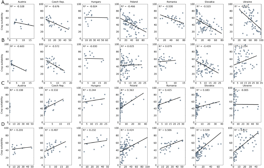
After adjusting our error estimates for class proportions, the validation suggested an overall high reliability with 90% overall accuracy despite the challenging class catalog (table 4). Most stable classes were mapped with user's and producer's accuracies of >80%. The best performing change class was grassland–forest conversions (G–F–F). Cropland–grassland conversion classes achieved high accuracies and conversion detected during the transition period achieved 86% producer's accuracy but a lower user's accuracy (65%).
Table 4. Validation results providing the confusion matrix as well as overall, user's and producer's accuracy for the change map derived from the analysis of the nine seasonal composites and spectral variance metrics. Columns show the reference samples while rows provide the classification results. The producer's accuracy relates to the number of reference samples correctly identified against all available reference points for that class, while the user's accuracy relates to the number of correctly classified samples against all samples classified as that class. (Note: the producer's accuracy was obtained from the area adjusted error assessment.)
| Overall accuracy | Reference | User's accuracy (%) | |||||||||||||||
|---|---|---|---|---|---|---|---|---|---|---|---|---|---|---|---|---|---|
| 90.29% | CCC | CCF | CCG | CFF | CGC | CGF | CGG | BBB | GGG | GCC | GFF | GGC | GGF | WWW | FFF | ||
| CCC | 39 | 1 | 2 | — | — | — | — | 1 | — | 1 | — | — | — | — | — | 88.64 | |
| CCF | 3 | 20 | — | 4 | — | 4 | 2 | — | — | — | 1 | — | 3 | — | — | 54.05 | |
| CCG | 7 | — | 26 | — | — | — | 5 | — | 3 | 1 | — | — | — | — | — | 61.90 | |
| CFF | — | — | — | 23 | — | 2 | 2 | — | 3 | — | 12 | — | 3 | 1 | — | 50.00 | |
| CGC | 19 | — | — | — | 13 | — | 1 | — | 3 | — | — | 1 | — | 1 | — | 34.21 | |
| CGF | — | 2 | — | 2 | — | 16 | 2 | — | 4 | — | 3 | — | 7 | — | — | 44.44 | |
| CGG | 5 | — | 5 | — | 2 | — | 30 | — | 4 | — | — | — | — | — | — | 65.22 | |
| BBB | — | — | — | — | — | — | 1 | 41 | 3 | — | — | — | — | 2 | — | 87.23 | |
| GGG | — | — | — | — | — | — | 1 | — | 43 | — | — | — | 1 | — | — | 95.56 | |
| GCC | 11 | — | 2 | — | — | — | 2 | 1 | 3 | 20 | — | 1 | — | — | — | 50.00 | |
| GFF | — | — | — | — | — | — | — | — | — | — | 48 | — | 1 | — | 1 | 96.00 | |
| GGC | 3 | — | — | — | — | — | — | — | 14 | 2 | — | 20 | — | — | — | 51.28 | |
| GGF | — | — | 1 | — | — | — | 1 | — | 2 | — | 8 | — | 32 | — | — | 72.73 | |
| WWW | — | — | — | — | — | — | — | — | — | — | — | — | — | 46 | — | 100.00 | |
| FFF | — | — | — | — | — | — | — | — | — | — | — | — | — | — | 49 | 100.00 | |
| Producer's accuracy (%) | 86.75 | 10.50 | 36.58 | 78.01 | 69.58 | 86.22 | 85.56 | 77.93 | 93.75 | 54.34 | 87.48 | 55.71 | 41.25 | 82.62 | 99.94 | ||
4. Discussion
We provide the first assessment of recent agricultural land change over the entire Carpathians at 30 m spatial detail. Our rates compare well to previous case studies in the region. For example, Kuemmerle et al (2009) detected 21% of abandoned cropland between 1990 and 2000. Our results suggest a somewhat higher abandonment rate of 29%. Likely reasons explaining these moderate differences are discrepancies in the abandonment definitions (the former study focused on cropland–grassland conversions while our study also considers cropland–forest conversions). Baumann et al (2011) assessed 46% of post-socialist farmland abandonment in the Ukrainian Carpathians (but for a smaller area) between 1986 and 2008, which is about 12% below our estimate. Moreover, our abandonment rates are highest in the mountainous districts, while Baumann et al (2011) found the highest rates to occur in the plains. The differences in spatial patterns likely result from different methodological approaches for change detection. Moreover, we used three observations per time step and therefore are more likely to capture land management (e.g. plowing, harvesting) compared to Baumann et al (2011) who used two images to characterize the 1980s. Regarding grassland conversion, a case study conducted in the Carpathians forelands in Hungary (Biró et al 2013) based on military survey maps assessed an annual conversion rate of 1.3% between 1988 and 1999 and a lower rate (0.35%) for the period from 1999 to 2010. While the first rate agrees very well with our current assessment of grassland conversion rates in the Hungarian part of the study region, our results do not suggest a large change in conversion rates for recent years (table 3).
Our change map had a relatively high accuracy despite complex change classes. This underlines the value of the Landsat archive and of the compositing approach, which allow assessing unprecedented detail of change patterns with satellite data at regional scales. However, a few sources of uncertainty remain. Generally, our approach works very well as long as the landscape elements (e.g. agricultural fields) provide sufficient spectral contrast in the different seasonal composites. But many agricultural areas underwent substantial structural changes that led to the fragmentation of large collectively managed cropland plots, accompanied by a diversification of ownership and crop types within small areas. If a large cropland plot in 1985 experienced such fragmentation, the reflectance signal subsequently becomes a mixture of different components (e.g. soil, grass, crop), which compromises accurate detection (Ozdogan and Woodcock 2006). In these cases, our approach may have detected some of the decrease in spectral contrast as, for example, a change from cropland to grassland.
Overall though, our results corroborate the extensive land changes that occurred throughout the Carpathians between 1985 and 2010. Cropland abandonment was most widespread and 24% of the 1985 cropland and a further 11% of the 2000 cropland were no longer cultivated in 2000 and 2010, respectively. According to our expectations, agro-ecological suitability showed strong linkages with agricultural abandonment and recultivation. The highest abandonment rates generally occurred on lands that are marginally suited for farming and in the years immediately following the collapse of socialism, as observed elsewhere in Eastern Europe (Mueller and Munroe 2008, Mueller et al 2009, Prishchepov et al 2013). This suggests that post-socialist cropland abandonment in the Carpathians was strongly contingent on socialist farming strategies that subsidized substantial expansion of agricultural land use in order to increase outputs. As a result, most cultivable land was used for farming, including marginal areas. The collapse of socialism led to a massive drop in state support for agriculture as well as adjustments in input and output prices (Rozelle and Swinnen 2004). Moreover, land reforms led to the privatization and restitution of agricultural land resulting in a large number of small fragmented farms particularly in mountainous regions (Lerman et al 2004). Combined, these changes grossly affected agricultural production and caused significant amounts of cropland abandonment throughout the Carpathians.
Interestingly, the rates of cropland abandonment tend to be higher in countries of the former Soviet Union than in Eastern Europe, similar to results from other studies. For example, cropland abandonment rates of up to 50% were found in the Baltics and in the Russian enclave of Kaliningrad (Nikodemus et al 2005), but abandonment was much lower in neighboring Poland (Prishchepov et al 2012a) and in the non-Soviet countries in our study region (all except Ukraine). Arguably, more determined support for agriculture during socialism in the former Soviet Union, including the nationalization of land, contributed to the extensive adaptation of land use after the collapse of socialism (Prishchepov et al 2013).
Recultivation concentrated in areas favorable for farming (as forecasted by Lakes et al (2009) for Southern Romania). Increasing profit opportunities in agriculture due to rising commodity prices since 2007 are likely the key underlying driver for the recultivation of cropland. Possibly, support through EU CAP contributed additional incentives for recent recultivation. In the coming years, expected further increases in agricultural commodity prices will likely provide additional incentives for recultivation of areas suitable for agricultural production. Furthermore, future biofuel production and the increasing demand for food, feed and fiber will compete with the requirement for nature protection in pristine landscapes like many parts of the Carpathian ecoregion. However, most future changes in land systems may not manifest in categorical changes of land use, as we have assessed, but in land use modifications (e.g. growing capital inputs in agriculture (Kuemmerle et al 2013)), which still pose considerable challenges for remote sensing based monitoring approaches (Lambin and Linderman 2006). Because crop yields are still modest in many areas of the Carpathian ecoregion, increasing land use intensity may translate into considerable production gains on currently used lands (Kuemmerle et al 2013).
Our results underline the value of the open Landsat archive for retrospective land change assessments and specifically the potential of seasonally tuned compositing approaches for mapping agricultural land change. This allowed assessing the major agricultural land change processes in an Eastern European setting, including cropland abandonment and recultivation. Both processes need to be equally considered here, as abandonment today only rarely represents a finite state of land change (Munroe et al 2013).
Acknowledgments
This research was funded by the Belgian Science Policy Research Program for Earth Observation STEREO II, contract SR/00/133, as part of the FOMO project (Remote sensing of the forest transition and its ecosystem impacts in mountain environments). PH's contribution to this research is part of his activities in the Global Land Project and the Landsat Science Team. TK acknowledges support through the Einstein foundation and the European Union (VOLANTE, FP7-ENV-2010-265104).